
What is Title Search: Process, Challenges, Automation and AI Best Practices
 Oct 5th, 2026

AI-powered real estate document processing converts fragmented property records from 3,100+ U.S. counties into structured, analytics-ready datasets using OCR, NLP, machine learning, and human validation to deliver 99% accuracy at 60-70% lower cost than manual workflows.
Table of Contents
Every real estate transaction generates a paper trail and AI-powered real estate document processing is the only scalable solution to manage it across 3,100+ U.S. counties.
According to the National Association of Realtors (NAR), there were 5.03 million existing home sales in 2022. Add to that commercial sales, foreclosures, permits and taxes, the sheer volume of documents creates operational chaos.
While the issue of volume itself is part of the challenge for property data providers, PropTech companies, insurance underwriting firms and investment firms, the larger problem lies in both the volume combined with lack of consistency and legacy formatting that makes manual-based workflows unaffordable economically.
For example, a firm attempting to obtain property information across only 50 U.S. counties may find that while some jurisdictions provide structured XML feeds of deed indexes. Other jurisdictions provide scanned deed book images using their own proprietary indexing systems. There is no standard schema used across jurisdictions.
By using Optical Character Recognition (OCR), Natural Language Processing (NLP), Machine Learning Classification and Human-In-The-Loop Validation through scalable processes, fragmented property records are converted into clean, analytics-ready structured datasets. These methods perform at rates and levels of accuracy that manual workflows could never accomplish.
This article describes how AI-powered real estate document processing functions, why it matters and what organizations can reasonably anticipate if they execute properly.
Real estate document processing refers to the process of systematically collecting and reviewing property-related documents from public records offices, governmental entities and privately owned resources. Once collected and reviewed, documents are classified, extracted, normalized, validated and then produced in a structured format.
When used in conjunction with Artificial Intelligence (AI), document processing enables automation of tasks that historically required considerable analyst time. AI-powered real estate document processing facilitates resolution of a fundamental conflict between the diverse array of raw data being received from multiple sources in numerous formats versus platforms that rely on receiving clean, consistently formatted data.
AI-based document classification must handle more than 150 distinct document types across the U.S. property records ecosystem, each with its own field structure, legal conventions, and extraction requirements which is why no single, general-purpose automation tool can cover the full scope.
Categories included in our document scope are:
Each document class contains unique fields, has its own set of legal conventions and requires different methods of extracting data. This explains why no single, general-purpose automation tool could accomplish the entire task and intelligent data extraction is the way to go.
| Field | RAW — County A (as received) | RAW — County B (same property) | SCHEMA-MAPPED OUTPUT |
|---|---|---|---|
| Property Owner | OwnerName1: SMITH JOHN A TR | TAXPAYER_NAME: Smith, John A. (Trust) | owner.primary_name: “John A. Smith (Trust)” |
| Street Address | SiteAddr: 123 N MAIN ST | SITUS_ADDR: 123 North Main St | property.street_address: “123 North Main Street” |
| Recording Date | RecDate: 04232019 | REC_DATE: 2019/04/23 | recording.date: “2019-04-23” |
| Document Type | DocType: WD | INSTRUMENT_TYPE: Warranty Deed | document.type: “Warranty Deed” |
| Parcel ID | APN: 4321-001-002 | PIN: 04-32-100-002-0000 | parcel.id: “4321001002” (normalised) |
County assessor portals, recorder offices, municipal permit databases, state court systems, federal agencies such as FEMA and USGS, produce data in an array of formats, including structured XML feeds & JSON APIs, scanned microfilm images and fixed-width legacy text files dating back decades prior to modern data standards.
Understanding these differences in source diversity is critical to appreciating just how challenging standardizing data can be.
Knowing that property documents exist is just the start. The harder question is why county property data across the U.S. resists standardization at scale, and the answer goes back a long way.
County land records in the United States have been kept independently at the local level for more than a century. No federal rule tells counties how to record, name, or format property data. So every jurisdiction built its own conventions, and those conventions have piled up over decades.
Regrid, a parcel data company that pulls records from all 3,143 U.S. counties, has mapped this fragmentation in detail. Field naming conventions, parcel identifier formats, and land use codes follow no industry-wide standard. What Los Angeles County calls an Assessor’s Parcel Number (APN), Cook County in Illinois calls a PIN. Other places use map-block-lot or township-range-section systems instead. Just normalizing address fields takes hundreds of jurisdiction-specific parsing rules.
Four structural factors drive this fragmentation.
Put together, these problems don’t bend to effort alone. Adding more analysts handles volume but not variability. Solving for variability takes AI systems built specifically for this domain, trained on large, diverse datasets of county property records, with processing pipelines designed around how that data actually arrives.
When we look at the entire life cycle of a property record, starting with the arrival of a raw county file and ending with a validated, schema-mapped record delivered to another application or platform, the true potential of data normalization and schema mapping will begin to show.
The end-to-end workflow consists of six separate phases, and each phase has to be accurate in order for the phase after it to also be accurate.
| Phase | Summary | Typical Latency | Failure Mode & Recovery |
|---|---|---|---|
| Phase 1: Data Ingestion | Collect data from SFTP, APIs, emails, portals, and scans. Log source, time, and format for traceability and compliance. | Near real-time to 24 hrs (source-dependent) | Source format change or portal downtime triggers automated alert; file held pending resolution |
| Phase 2: Classification & Indexing | ML models classify documents (deeds, liens, permits). Confidence scores flag uncertain cases for review. | Seconds per document | Low-confidence routes to HITL queue; does not block other documents |
| Phase 3: Extraction | OCR and NLP extract key fields from structured and unstructured data based on document type. | 0.5–5 seconds per document | Degraded image quality reduces OCR confidence; HITL threshold activates automatically |
| Phase 4: Normalization | Standardize formats (dates, addresses, values) and map county-specific fields to a unified schema. | Milliseconds | Unmapped field triggers rule-engine flag; ML suggestion offered for new jurisdiction |
| Phase 5: Validation & Scoring | Apply rules for accuracy and consistency. Low-confidence records go for human review. | 4–8 hours for HITL-flagged records | Systematic accuracy drop triggers pipeline pause and downstream consumer alert |
| Phase 6: Structured Output | Deliver clean, validated data via APIs, SFTP, or pipelines for analytics and systems use. | API: real-time; SFTP/batch: configured schedule | Delivery failure triggers automatic retry with full audit trail logged |
PIPELINE SUMMARY
This process is financially feasible for commercial-scale deployment nationwide due to the combination of technologies rather than individual technologies. While there are some limits associated with each layer, each layer helps compensate for the limits of the previous layer, thus making the technological stack critical, along with the workflow design.
There are six unique artificial intelligence (AI) and engineering functions that operate together within real estate document processing solutions or systems. To determine if any evaluation of any solution includes a suitable technical stack, understanding what each capability provides, and why no generic tool can provide what a purpose-designed tool is capable of providing, is essential.
| Technology | Role in Real Estate Document Processing |
|---|---|
| OCR for Property Documents | Extracts text from scanned deeds, microfilm archives, and degraded records. Deep learning OCR engines built on transformer architecture achieve 99%+ accuracy on standard typed documents and 95%+ on historical or degraded scans, a significant improvement over earlier rule-based systems. |
| NLP for Real Estate Data | Parses dense legal language, legal descriptions, covenants, conditions, and restrictions. Named entity recognition (NER) models fine-tuned on real estate corpora identify parcel IDs, addresses, and monetary amounts even in free-form narrative text. |
| Machine Learning | Supervised models classify documents and extract field-level data. Ensemble methods combining multiple model outputs outperform single-model approaches on edge cases. Transfer learning from large pre-trained models reduces the labelled data required for new document types. |
| Computer Vision | Addresses document structure beyond character recognition identifying table boundaries in assessor exports, detecting form layouts in permit applications, and recognizing recording stamps and signatures. Layout analysis before extraction significantly improves accuracy on multi-column formats. |
| Human-in-the-Loop (HITL) | A designed pipeline component, not a fallback. Review queues surface low-confidence extractions for expert correction. Those corrections feedback as training data, creating a continuous improvement loop that progressively reduces the volume requiring human review. |
| Confidence Scoring | Every extracted field carries a numerical score. Downstream consumers apply thresholds per use case: 85% for bulk aggregators, 99%+ for mortgage underwriting. Confidence-gated workflows direct human attention precisely where it adds the most value. |
Once a suitable technical stack is developed, the focus shifts from extracting data to validating that the extracted data is both trustworthy and usable at scale which is where standardizing and ensuring acceptable data quality become the key determining factors.
Extracting data is one aspect. Ensuring that data is coherent across 3,100+ jurisdictions such that a parcel record from Maricopa County, AZ is directly comparable to a parcel record from Miami-Dade County FL, is the larger problem. Ultimately, this is a problem related to data standardization and is comprised of three layers.
This defines the mapping of source field(s) for each county’s source data to a universal target schema. This mapping requirement must be accomplished for all 3,100+ US Counties. Using automated rule engines for well-understood mappings coupled with using machine learning assisted suggestion for recently added jurisdictions, provides the means to accomplish this massive mapping effort.
MISMO’s Reference Model v3.6 establishes field naming conventions and data type consistency for mortgage workflows, yet no equivalent standard exists at the county recorder level, necessitating jurisdiction-specific mapping configurations.
Regrid (which extracts parcel data from all 3,143 US Counties) states that their standardization efforts are conducted “manually, county by county,” which underscores the need for encoded jurisdictional knowledge at scale in automated pipeline processes.
One of the leading causes of data breaks downstream in data processing pipelines is inconsistent address representation. For example: the same property may be represented differently depending on the source system: ‘123 n main st unit 4b’, ‘123 north main street #4b’ and ‘123 north main st apt 4b’.
By utilizing USPS based standardization coupled with geocoding validation data consumers are able to obtain consistent address representations and ensure that records are resolvable through spatial joins and proximity analysis all of which are essential for the development of PropTech applications.
Finally, when the same transaction is recorded in both assessor and recorder records (as is typically the case), probabilistic matching using combinations of parcel IDs, addresses and recording dates assists in identifying duplicate transactions without losing information thus ensuring that all available information is preserved throughout the extract process.
At national level, the total universe of property records includes approximately 160 million parcels distributed across 3,143 counties (as per Regrid’s existing dataset). Using cloud-native architecture and horizontal scaling allows for processing of extracted county-clustered data in parallel. Additionally, alert mechanisms for source failure and format changes provide downstream consumers with complete visibility regarding the timeliness of each county-dataset.
While the case for AI document processing has been demonstrated through measurable improvements in different outcomes, Hitech BPO scaled property record processing across 345 counties too.
Here is how the benefits have been realized, and where they are materialized in practice:
| Benefit | What Changes | Business Impact |
|---|---|---|
|
Data Accuracy |
HITL + validation reduce field errors to sub-1% vs. 2–5% for manual entry |
99% accuracy using intelligent data processing, higher analytics trust; fewer costly downstream data incidents |
|
Processing Speed |
Thousands of documents per hour vs. tens per analyst-day |
Faster time-to-insight; datasets refreshed at county recording cadence |
|
Cost Efficiency |
60–70% reduction in per-record processing cost |
Expand county coverage without proportional headcount growth |
|
Coverage Breadth |
Automated connectors scale to any U.S. county |
National datasets become commercially viable for the first time |
|
Analytics Readiness |
Schema-mapped output ingests directly into analytics platforms |
Analysts focus on insight, not data cleaning |
These benefits have manifested themselves in five high-value use cases:
Institutional market intelligence can track permit activity as a leading investment indicator, map areas containing delinquent taxpayers, and identify early signs of appreciable price growth before they appear in published indexes.
Technologies supporting real estate document processing continue to advance. Three emerging technologies will significantly influence what can be achieved by next-generation document pipelines and how rapidly actionable data can be made available to those platforms dependent upon it.
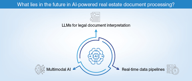
Fine-tuning LLMs on large corpora of legal documents enables stronger generalization capabilities to complex legal language. Examples include covenant analysis, restriction parsing, and grantor clause interpretation.
Before the advent of LLMs, extensive labelled training data was required to train earlier versions of NLP models. Rag (retrieval-augmented generation) approaches represent strong candidates for minimizing hallucination risk associated with AI-based real estate data extraction for fetching legal descriptions from complex legal documents.
Text-and-image models capable of processing both content and structure of visual elements simultaneously will allow survey plans, site plans and property maps to be processed in a single inference pass. Currently, these types of documents require separate computer vision pipelines. Reduction of pipeline complexity and improved accuracy on spatially complex formats will depend on multimodal AI models.
Once you automate real estate data pipelines, they operate primarily through batch refresh cycles: daily, weekly or monthly. The use of event-driven architectures that allow new recordings to be consumed within minutes of county filing will enable title monitoring, lender alert systems, and early warning systems for tax delinquencies. This is not practically possible with batch-refresh-only data pipelines.
Ultimately, emerging technologies point towards an environment where the gap between county recording and analytics-ready data will contract to near zero. Also, processing platforms will evolve into integrated data-plus-analytics environments that automatically update valuation models and trigger investment alerts based upon receipt of new records.
AI-powered real estate document processing is mission-critical infrastructure for any organization that depends on accurate, timely property data at scale. It is not just a feature upgrade.
Organizations competing for long-term market share advantage in PropTech, real estate investment, and data services during the next decade will be those developing or otherwise forming partnerships with providers of intelligent and continuously evolving data pipelines. The applicable technologies have already proven themselves successful.
Established use cases demonstrate their feasibility. Economics clearly indicate this course of action makes sense. It is time to act and build in consonance with the new AI dynamics in place!
The questions below are representative of many of the most common areas of uncertainty for evaluation teams looking at using AI to automate the processing of real estate documents, including both technical and operational issues.
What’s next? Message us a brief description of your project.
Our experts will review and get back to you within one business day with free consultation for successful implementation.

Disclaimer:
HitechDigital Solutions LLP and Hitech BPO will never ask for money or commission to offer jobs or projects. In the event you are contacted by any person with job offer in our companies, please reach out to us at info@hitechbpo.com