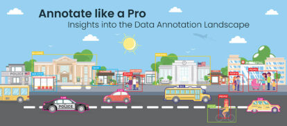
Annotate location data to power AI and ML models


Tailored geospatial data annotation services that ensure your AI and ML applications leverage the full potential of location-based information.
At HitechBPO, we specialize in converting raw geospatial data into structured, high-quality training datasets that power AI and ML models. Our experts use a wide range of annotation techniques, including bounding boxes, semantic segmentation, polygon annotation, polylines, keypoints, image classification, and object tracking to handle satellite imagery, LiDAR data, maps, and more.
Our flexible solutions – from small-scale project assistance to large-scale data annotation initiatives – all quality driven. We have the expertise and experience to ensure high labelling accuracy in geospatial training data, whether for object detection, terrain and land-use mapping, autonomous navigation, infrastructure management, environmental monitoring, or other purposes. We employ stringent quality checks and human-in-the-loop processes to deliver consistently reliable results, even for complex geospatial AI projects.
Discuss your geospatial data annotation project with us »Our suite of geospatial data annotation services is designed to cater to the diverse needs of AI and machine learning in geospatial analysis:
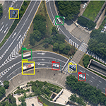
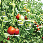
Precise annotation of objects of interest in satellite images, for accurate object detection and localization.
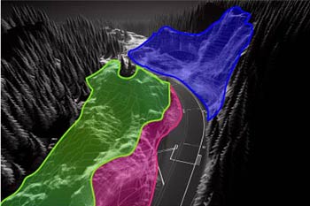
Classify each pixel in an image for detailed land-use analysis, environmental monitoring, and to analyze geographical features.
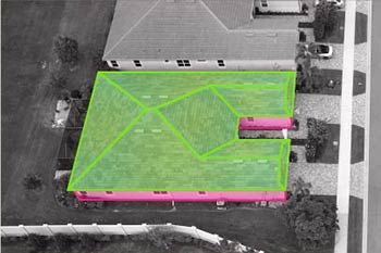
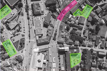
Precisely outline complex geographic features, facilitating detailed analysis of land use and infrastructure.
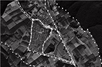
Annotate linear features and mark roads, infrastructure and key landmarks for mapping, navigation and route optimization.
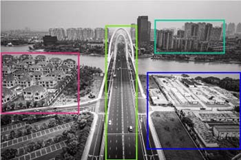
Categorize geospatial imagery into predefined classes, for land-use mapping, change detection and geospatial pattern analysis.
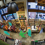
Annotate objects across video frames to improve tracking algorithms in geospatial applications.
Gathering relevant geospatial imagery and data tailored to your project needs.
Employing advanced techniques for accurate labeling and categorization of geospatial data.
Rigorous quality checks to ensure high accuracy and reliability of annotated data.
Implementing stringent data security measures to protect the privacy and integrity of geospatial data.
Seamlessly integrating annotated data into AI models for enhanced geospatial analysis and applications.
Geospatial Data Annotation Services for various industries and domains.

Tailored to meet specific AI and ML requirements in geospatial analysis, ensuring the models are trained with relevant and accurate data.

Our services are scalable to handle large volumes of geospatial data and flexible to adapt to various annotation needs, ensuring efficiency in every project.

Whether it’s machine learning for geospatial analysis or AI in environmental monitoring, our.

Our geospatial data annotation services are competitively priced, offering you high-quality solutions without compromising on accuracy or efficiency.
FAQs Geospatial Data Annotation
What is geospatial data annotation and why is it important?
What types of geospatial data can be annotated?
How is geospatial data annotation used in AI development?
How much does geospatial data annotation cost?
How can I ensure the quality and accuracy of geospatial data annotation?
What are the ethical considerations of geospatial data annotation?
What are the future trends in geospatial data annotation?
How can I find the right geospatial data annotation provider?
What’s next? Message us a brief description of your project.
Our experts will review and get back to you within one business day with free consultation for successful implementation.
Disclaimer:
HitechDigital Solutions LLP and Hitech BPO will never ask for money or commission to offer jobs or projects. In the event you are contacted by any person with job offer in our companies, please reach out to us at info@hitechbpo.com